
🌍 Geography of Pakistan
🌍 Geography of Pakistan: A Complete Description
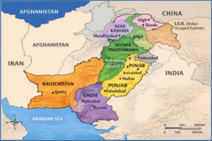
1) Overview of Pakistan’s Geography
Geography is the study that deals with the location of countries, cities, rivers, mountains, and lakes. Pakistan is a land of remarkable diversity and strategic significance. It is situated between latitude 24 and 37 degrees North and longitude 62 and 75 degrees East. The country finds itself at a historic crossroads, bordered by Iran to the West, India to the East, Afghanistan to the North West, and China to the North, with the Arabian Sea forming its southern boundary. This position astride the ancient trade routes between Asia and Europe has shaped its history and culture.
Pakistan’s territory spans approximately 796,095 square kilometers (or 803,940 sq km including FATA and FANA), presenting a breathtaking variety of landscapes. This vast area encompasses everything from arid deserts and stark plateaus to lush, irrigated plains, fertile river valleys, and some of the world’s most formidable mountain peaks. Geographically, the country can be broadly divided into three major regions: the fertile lowlands along the Indus River in the south and east, the arid and rocky plateau of Baluchistan in the southwest, and the magnificent, glacier-covered mountains of the north.
The northern mountainous region is truly spectacular, containing K2 (Mount Godwin-Austen), which at 8,611 meters (28,250 feet) is the second-tallest peak on Earth. This region is home to over 300 glaciers and is dominated by three of the world’s great mountain ranges: the Himalayas, the Karakoram, and the Hindu Kush.
In contrast, the provinces of Punjab and Sindh in the east and south form the agricultural heartland of the nation. These areas are well-irrigated by the mighty Indus River and its network of tributaries—the Jhelum, Chenab, Ravi, and Sutlej. These rivers converge and flow southwards into the Arabian Sea, depositing rich silt that creates incredibly fertile land. This region produces most of Pakistan’s food and is the most densely populated part of the country. It hosts the nation’s most prominent cities, including Karachi (the largest city and main port), Lahore (a cultural and historical center), Islamabad (the modern capital), and Rawalpindi.
Physical Features of Pakistan
🌄 The Northern Mountain Ranges
The north of Pakistan is a fortress of towering mountains. Two of the most famous ranges are the Himalayas and the Karakoram. Within Pakistan, the highest peak of the Himalayas is the majestic Nanga Parbat, which soars to an elevation of 8,126 meters above sea level and is often called the “Killer Mountain” for its challenging climbs. The Karakoram range boasts the legendary K2, which at 8,611 meters is not only the highest peak in Pakistan but also the second-highest on Earth. A third major range, the Hindu Kush, stretches across the northwest. Its highest point in Pakistan is Tirich Mir, standing at 7,690 meters.
⛰️ The Western and Central Ranges
On the western frontier, the Sulaiman Range runs north to south, with its highest point being Takht-e-Sulaiman (Throne of Solomon) at 3,487 meters. Further south, separating the provinces of Balochistan and Sindh, lies the Kirthar Range, with a maximum height of 2,150 meters. In the heart of Punjab, the Salt Range is a historically and geologically significant low mountain range, rich in mineral deposits, with a maximum height of 1,522 meters.
🌾 The Indus Plain
South of the Salt Range and east of the Suleiman and Kirthar mountains lies the vast and vital Indus Plain. This expansive alluvial plain stretches all the way to the Arabian Sea and is the lifeline of Pakistan’s agriculture. It is irrigated by the Indus River system. The area is divided into the Upper Indus Plain (Panjnad region above Mithankot, where the five rivers meet) and the Lower Indus Plain (the area south of Mithankot down to the delta). This plain is the most productive and densely populated region of the country.
🏞️ The Plateaus
The Balochistan Plateau
West of the Suleiman and Kirthar mountains lies the extensive Balochistan Plateau, which covers almost half of Pakistan’s total territory. This is a stony, barren, and sparsely populated tableland with an average height of 600-900 meters. The Toba Kakar and Chagai hills separate it from Afghanistan. It is an extremely dry region with no major river system; the Zhob River is one of the few, flowing into the Gomal. The area contains the saltwater Hamun-i-Mashkel Lake. Despite its aridity, the plateau is rich in minerals such as coal, natural gas, chromite, iron, and copper.
The Potwar (or Pothohar) Plateau
North of the Salt Range, between the Indus and Jhelum rivers, lies the Potwar Plateau. It is a picturesque, undulating tableland bounded by the Kala Chitta Range, Margalla Hills, and the Salt Range. This geographically diverse area includes the districts of Rawalpindi, Attock, and Jhelum. It is irrigated by two small rivers, the Swan and the Haro, which eventually drain into the Indus. The plateau is known for its multi-colored, rugged terrain.
🏜️ The Deserts
Pakistan is home to several significant desert regions:
-
The Thar Desert: Located in southeastern Pakistan (Sindh and Punjab), this is the largest desert in Pakistan and the only subtropical desert in Asia. It spans approximately 175,000 square kilometers, featuring a very dry western section (Marusthali) and a slightly less arid semi-desert region in the east.
-
The Thal Desert: Situated in the Bhakkar district of Punjab between the Indus and Jhelum rivers. Large-scale irrigation projects are underway to transform parts of this desert into farmland.
-
The Kharan Desert: Located in northwestern Balochistan, this is a distinct sandy desert basin covering over 19,000 square kilometers, characterized by an even, sandy terrain unlike the rocky plateau surrounding it.
🏖️ Coastal Areas
Pakistan’s coastline stretches for about 1,000 kilometers along the Arabian Sea, from the marshy Rann of Kutch in the east to the border with Iran in the west. A striking feature is the Makran Coastal Range, a narrow strip of steep mountains that runs along roughly 75% of the coast, rising up to 1,500 meters and creating a dramatic meeting of land and sea.
Population and Climate
Population
According to the 2017 census, Pakistan has a population of approximately 208 million people. The population growth rate is around 1.95%, with a density of 251 people per square kilometer. The gender ratio is recorded as 108 males for every 100 females.
Climate
Pakistan’s climate is as diverse as its topography, varying tremendously with elevation and location.
-
In the northern mountains, the months from April through September are pleasant, while winters from December to February are harsh and freezing.
-
On the low-lying Indus Plain, the same summer months bring oppressive heat, with midday temperatures frequently exceeding 40 degrees Celsius (104°F). The winter months are much cooler, with temperatures ranging from 10-25°C (50-77°F).
-
The monsoon rains arrive in the southern parts of the country in late summer, but precipitation remains minimal in Balochistan and limited in most interior regions, contributing to the aridity of the plateau and deserts.